ARE YOUR DISASTER PLANS AS STRONG AS LAST YEAR’S LUCK? PREPARING FOR THE 2026 HURRICANE SEASON
As Hurricane Season 2026 approaches, the THF (Thomas Howell Ferguson P.A. CPAs) Government Consulting Services Team remain focused on one priority: strengthening readiness and sustaining resilience. One quieter season does not reduce risk, it reinforces the importance of discipline and proactive planning.
LOOKING BACK AT 2025
While the 2025 Atlantic hurricane season produced multiple strong storms, no hurricanes made landfall in the continental United States or in Florida, marking the first such outcome since 2015. That outcome was a result of atmospheric steering patterns, not a lack of active systems. Powerful storms still formed, underscoring that risk and uncertainty remain inherent to this region.
In response, our team at GCS has been diligently preparing for the 2026 hurricane season. Staff have been completing the Professional Development Series offered through the Federal Emergency Management Agency (FEMA) and staying current with 2 CFR 200 changes.
In addition, we have completed multiple tabletop FEMA exercises simulating real hurricane scenarios, allowing GCS to reinforce our knowledge of the procedures and response times critical in these moments. We remain dedicated to strengthening our readiness and resilience to better serve our clients should any disaster occur this year.

INTEREST COST FOR COOPERATIVES
We have worked closely with our electric cooperative clients to navigate the complexities of recovering interest costs associated with major storm events. Our team brings a practical, solutions-driven approach that aligns real-world utility operations with FEMA requirements. By understanding how our clients actually operate and account for storm work, we help them capture costs that might otherwise be overlooked. The result is a stronger recovery position and more funding returned to the communities they serve.
— EARLY FORECAST FOR 2026 —
Near-average activity projection
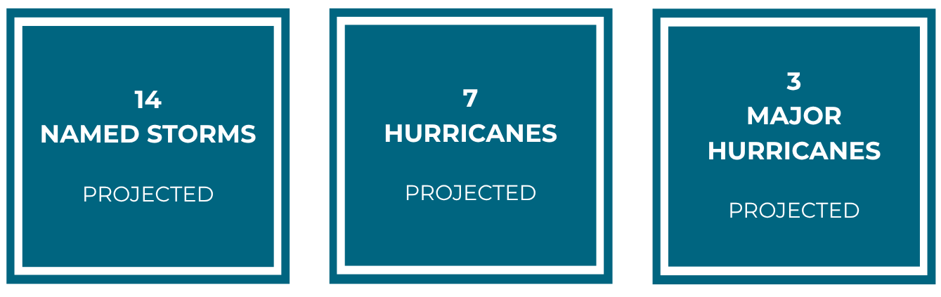
This early outlook comes with high uncertainty, seasonal forecasts are inherently variable this far ahead of June 1st and shifts in large-scale climate patterns could alter storm frequency and intensity as the year unfolds, such as the potential for El Niño conditions developing during the season.
To stay ahead of every shift, our team monitors conditions in real time through our dedicated ‘war room’, where Mike’s Weather Page is a constant on our screens and a trusted part of how we track the season as it develops. We are also actively investing in our specialties by attending multiple emergency management events this year including Florida Emergency Preparedness Association (FEPA), Florida’s Training for Emergency management (FTEM), Emergency Management Days, National Emergency management Association (NEMA), and Federal Emergency Management Agency (FEMA) training courses to continue strengthening our approach and skills as a team.
EXCELLENCE IN ACTION

The 2026 Emergency Management Days at the Florida State Capitol showcased this year’s theme: Excellence in Action, a standard that THF has embraced as a core organizational objective. We are always prepared to serve our clients when disaster strikes.
A strategic plan is only as strong as its execution. At THF, we maintain a comprehensive portfolio of emergency response plans, each developed and refined to be deployed at a moment’s notice.
One recent example of this commitment in action was a drone demonstration led by one of our FAA Part 107 Certified Remote Pilots. From assessing storm damage and enhancing situational awareness to supporting search and rescue operations, drone technology empowers emergency management teams to respond with greater speed and make more informed decisions in real time.
This capability is just one of many that THF has ready to deploy because when our clients need us most, we will be ready.
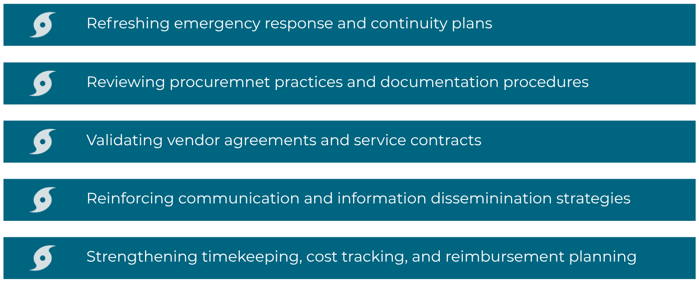
— PREPAREDNESS IS A DISCIPLINE —
Being ready in2026 means more than looking at numbers and probabilities. It means:
WHAT IS NEW FOR 2026?
The National Hurricane Center (NHC) is issuing new forecast cone graphics for the 2026 hurricane season. The NHC says that tropical cyclone graphic helps communities, including those inland, stay aware of wind hazards from hurricanes and tropical storms. Starting in 2026, the forecast cone will display tropical storm and hurricane watches and warnings for inland areas, following a successful trial last year that showed the update helped inland residents better understand and prepare for approaching storm winds. The updated cone will expand its coverage to capture 90% of possible forecast tracks, a large increase compared to the traditional 67%.
“These improvements empower communities to prepare earlier and more effectively for dangerous hazards from tropical storms and hurricanes,” said Michael Brennan, Director, NOAA’s National Hurricane Center.
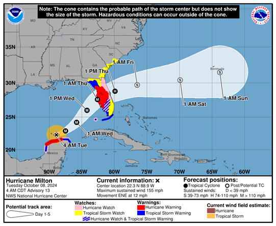
(Image credit: NOAA National Hurricane Center)
This update is particularly valuable for residents and businesses in hurricane-prone regions, providing clearer guidance to support preparedness efforts. The forecast shown above illustrates the new cone format from the NHC, as demonstrated during Hurricane Milton (2024). THF currently serves several clients who continue to navigate the long-term impacts of Hurricane Milton, and it is encouraging to consider that this enhanced forecasting tool may help reduce the burden on affected communities when the next storm occurs.
2026 ATLANTIC HURRICANE SEASON NAMES

Preparedness is not reactive. Resilience is not accidental.
The 2025 season provided breathing room. 2026 demands continued discipline.
Start now · Stay ready · Strengthen what matters
If you would like assistance reviewing your preparedness or recovery strategies, our Government Consulting Services Team is ready to help you prepare.